
The Submittal Package: The Site [Plot] Plan
Putting together a submittal package can be a daunting endeavor with the multitude of required forms and other documents necessary for plan review and permit approval. Some documents require preparation by a licensed professional while others can be created by the applicant alone.
The Site, or plot plan falls into this latter category and is one reason why they are not included as standard within the typical set of plans. The typical building permit application provides a blank space specifically for the applicant to draw in their own site plan and does not require a survey be performed.
A site plan only needs to represent the parcel of property and the various existing and proposed structures including their main wall lengths and the distances from the closest projections of those structures to the property lines. Decks, Septic systems and their drain fields, wells and road/driveways should also be shown. Unnatural Landscaping features are typically not necessary, but varies with each jurisdiction.
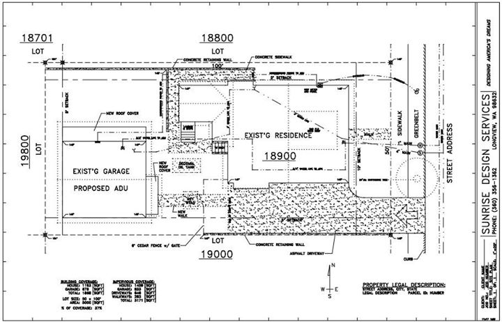
All properties have basic setback requirements, areas around the perimeter of the property that proposed structures cannot encroach upon without increasing the structures fire-rating. These setback distance requirements are different for the rear, side and front property lines and can vary from county to county and city to city.
Whether you choose to create your own site plan or have it included as part of your plans package, they are required to be provided on a smaller paper size than the construction plans. Typically this is no larger than 11×17” or “Ledger” sheet size although a letter-sized 8.5×11” sheet can be used also.
In either case site plans are required to be drawn to a scale, usually 1:10 or 1:20 for the average lot. Larger parcels with acreage may need a 1:50 scale.
In producing a site plan for our clients a site visit is rarely needed. Using client-provided site measurements and a site address, local records searches and online GIS-mapping will usually provide the remaining pertinent information needed including elevation and slope data. A pdf-format file is provided in the proper scale and sheet size, ready to be printed for your submittal package.